iFlightPlanner


...

Blog

Thursday, April 30, 2015

FAA Airport, Navigation & Chart Data is Current for 4/30 Cycle

Thursday, April 30, 2015 @ 4:01 AM

Official airport, navigation and chart data for the FAA's 56-day cycle beginning 4/30/15 became current today as of 09:01Z.  This includes updated georeferencing data for airport diagrams and instrument approach procedures available in iFlightPlanner for iPad.

Anytime you access iFlightPlanner.com or mobile.iFlightPlanner.com you can be confident that you are seeing the most current and accurate data available.  To ensure that iFlightPlanner for iPad is current, simply tap "Check for Updates" in the upper-left corner of the Downloads tab.  The app will quickly tell you which packages need to be updated!

The iFlightPlanner Crew
PLAN. FLY. LOG.

Wednesday, April 29, 2015

AeroWeather Now Featuring iFlightPlanner Airports, VFR & IFR Charts

Wednesday, April 29, 2015 @ 8:00 AM

With the latest releases to AeroWeather Lite and AeroWeather Pro for iPhone and iPad, users will now have direct access to iFlightPlanner's Airport/Facility Directory and freely accessible VFR and IFR Low charts!

AeroWeather provides current and precise weather conditions for airports worldwide, searchable by either name or ICAO code and is a great companion to iFlightPlanner.com, mobile.iFlightPlanner.com and iFlightPlanner for iPad for pilots needing weather information outside of the United States. 

Monday, April 27, 2015

iFlightPlanner Introduces Garmin GTN Flight Plan Compatibility

Monday, April 27, 2015 @ 8:00 AM

iFlightPlanner recently announced the availability of new functionality that allows pilots to create and save flight plan files for use in the new GTN 600 and 700-series avionics by Garmin.

This innovative technology eliminates the need for pilots to manually enter complex routes.  Instead, pilots can simply save a GFP file from iFlightPlanner.com to a compatible SD Card, then follow the step-by-step instructions found in the Garmin Pilot’s Guide for their particular unit to activate or store the route files.

“iFlightPlanner is very excited to be the first flight planning resource offering file export capabilities for use in the Garmin GTN series of avionics,” said Andy Matthews, iFlightPlanner’s Co-Founder & Director of Business Development.  “Safety, usability and flight planning efficiency are at the core of every new feature we develop and we believe our membership will find this technology to be an incredible asset to their flying.”

iFlightPlanner has been a leader in flight plan file creation since it first introduced this type of functionality for its members in 2012, with GFP compatibility building on iFlightPlanner’s existing FPL flight plan file creation for Garmin’s G1000 and 430/530 avionics packages.  Collectively iFlightPlanner now supports five (5) different file formats – Garmin GFP and FPL, GPX, GPX for AvMap and the FMS flight plan file format used in the popular X-Plane Flight Simulator by Laminar Research.

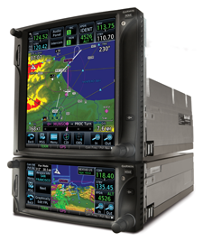
The GFP format is compatible with the GTN 625, 635, 650, 725 and 750 models running software version 5.10 or later and requires an iFlightPlanner Premium or Premium Plus membership.  It should also be noted that the GFP must be saved to a folder named “FPL” on the root of the SD Card as that is where the GTN models will look for the files.

iFlightPlanner Premium memberships with route export capabilities start at just $9.99/month and include access to iFlightPlanner’s cloud-based flight planning technology across all of its platforms, including iFlightPlanner for iPad.  iFlightPlanner Free memberships are available with no obligation and allow pilots to leverage much of iFlightPlanner’s web-based technology with limited, read-only functionality on the iPad.  A one-time, 30-day free trial to iFlightPlanner Premium is available via the App Store.

The iFlightPlanner Crew will be in Lakeland, FL at SUN ‘n FUN from April 21–26 in Booths D-011 and D-012. Pilots are encouraged to stop by for their personal demonstration or visit https://www.iFlightPlanner.com for more information.

Monday, April 20, 2015

SUN 'n FUN 2015, Cleared for Takeoff!

Monday, April 20, 2015 @ 1:20 PM

Believe it or not we can file a flight plan even faster than we can setup for SUN 'n FUN! ...big thanks to Gator Cases for helping us get the gear to Lakeland Linder Regional Airport (KLAL) in one piece!  Come visit us in Hangar D, Booths D-011 & D-012 for a look at what's new from iFlightPlanner!

Believe it or not we can file a flight plan even faster than we can setup for Sun 'n Fun! ...big thanks to Gator Cases for helping us get the gear to Lakeland Linder Regional Airport in one piece!See you all Tuesday in Hangar D, Booths D-011 and D-012!

Posted by iFlightPlanner on Sunday, April 19, 2015

LiveATC.net at SUN 'n FUN 2015

Monday, April 20, 2015 @ 8:00 AM

It's going to be a busy week at Lakeland Linder Regional Airport (KLAL) for SUN 'n FUN!  Be sure to tune in to LiveATC.net for ten (10) great audio streams, including SUN 'n FUN Radio and the USAF Thunderbirds!

LiveATC.net provides a quick and easy way to listen in on live conversations between pilots and air traffic controllers near many airports around the world.  It lets you easily browse by U.S. state, Canadian province, or by country to find an airport of interest.

Wednesday, April 15, 2015

iOS 8.3 GPS Accessory Bug

Wednesday, April 15, 2015 @ 8:00 AM

There is a nasty bug in iOS 8.3 which blocks position information coming from Bluetooth GPS devices.  The symptom is that your GPS looks like it is working, but your apps do not show your location - not all apps are affected, but most are.  

The problem affects the XGPS150, XGPS160 and XGPS170 from Dual as well as Bluetooth GPS devices from other manufacturers such as Bad Elf and Garmin.  Greg Lukins, Vice President of Business Development at Dual Electronics said, "We have contacted Apple, filed a bug report and they are aware of the issue.  Unfortunately we do not have a timeline for a fix but they are treating it as a priority."

In the meantime, some users are getting around the bug by turning off Location Services, rebooting the iOS device, and turning Location Services back on.  "It's not a surefire workaround and it's not working for everybody," added Lukins.  "For those who have yet to install the iOS 8.3 update it is recommended that you wait until Apple releases an updated version of the iOS."

Monday, April 13, 2015

ADS-B Survey for Aircraft Owners

Monday, April 13, 2015 @ 8:00 AM

Embry-Riddle Aeronautical University is conducting a research study to measure the perceptions and motivations of aircraft owners and operators in response to the ADS-B out mandate, including pilots' opinions about installation costs.  

» Aircraft Owner ADS-B Out Survey

The study is lead by Dr. Kenneth P. Byrnes, Chairman of the Flight Training Department and Associate Professor in Aeronautical Sciences at ERAU.  Findings are intended to assist the FAA Equip 2020 working group to understand the level of knowledge as well the plans of ADS-B Out equipage among aircraft owners and operators.

Wednesday, April 8, 2015

Unboxing the Icom IC-A6 VHF Air Band Transceiver

Wednesday, April 8, 2015 @ 8:00 AM

The iFlightPlanner Crew recently got their hands on the IC-A6 VHF Air Band Transceiver from Icom and thought it would be fun and informative to share our unboxing and setup experience with the new unit.

Icom touts the A6 as the simplest, most easy to use handheld on the market.  Its big brother, the IC-A24 shares the same frame but features NAV features in addition to COM for U.S. frequency ranges.  Both the A6 and A24 have well-labeled, large keypads that allow for user friendly operation in flight.  The large displays are capable of showing both letters and numbers making for fast frequency recognition, and both the display and keypad are backlit and will stay on until you turn it off – a very handy feature for flying at night!

The contents of the box itself are extremely well organized and hardly require the instruction manual to get started.  The unit weighs 15.2oz once the battery and antenna are installed, and the weight and water-resistant construction of the A6 instills confidence that it will withstand a few bumps and bruises without any problems.  The company website has the full specifications.  Supplied accessories include the antenna, belt clip, handstrap, battery pack, wall charger and headset adapter.  You'll need a small Phillips head screwdriver to attach the belt clip to the battery pack that is not included.

Holding the PWR button for a couple seconds will turn the unit on and you're good to go!  The left-most nob is reserved for volume, and the other (marked DIAL) is used for tuning the desired frequency, WX channel number, BANK number and memory channel.  It also controls the squelch and beep tone level.  All of the features are clearly detailed in the instruction manual with diagrams, graphics and helpful key sequences so that you can get the most out of the A6.

Additional Features Include:

  • 200 memory channels (20 Ch × 10 banks) with 6 character names
  • Dedicated 121.5MHz emergency key
  • Side tone function allows you to hear your own voice via an external aviation headset
  • Optional Ni-Cd and Li-Ion battery packs
  • NOAA marine weather channels
  • Tag scanning and memory bank scanning
  • ANL (Auto Noise Limiter) for noise reduction
  • Low battery alert

Icom does not do direct sales through their website, but they will help you find their nearest authorized avionics dealer where you can purchase one.  Most retailers have the A6 listed around $240 but the company is offering a $30 rebate through the end of May 2015.  At that price you'll be hard-pressed to find a more versatile handheld transceiver with the versatility and reliability than the Icom A6!

Monday, April 6, 2015

Airplane Flying Handbook, FAA-H-8083-3B

Monday, April 6, 2015 @ 8:00 AM

The Airplane Flying Handbook (FAA-H-8083-3B) is designed as a technical manual to introduce basic pilot skills and knowledge that are essential for piloting airplanes.  It provides information on transition to other airplanes and the operation of various airplane systems.  It is developed by the Flight Standards Service, Airman Testing Standards Branch, in cooperation with various aviation educators and industry.

This handbook is developed to assist student pilots learning to fly airplanes. It is also beneficial to pilots who wish to improve their flying proficiency and aeronautical knowledge, those pilots preparing for additional certificates or ratings, and flight instructors engaged in the instruction of both student and certificated pilots, and best of all is available for download as a FREE reference via FAA.gov.

Thursday, April 2, 2015

FAA Airport, Navigation & Chart Data is Current for 4/2 Cycle

Thursday, April 2, 2015 @ 4:01 AM

Official airport, navigation and chart data for the FAA's 28-day cycle beginning 3/5/2015 became current today as of 09:01Z.  This includes updated georeferencing data for airport diagrams and instrument approach procedures available in iFlightPlanner for iPad.

Anytime you access iFlightPlanner.com or mobile.iFlightPlanner.com you can be confident that you are seeing the most current and accurate data available.  To ensure that iFlightPlanner for iPad is current, simply tap "Check for Updates" in the upper-left corner of the Downloads tab.  The app will quickly tell you which packages need to be updated!

The iFlightPlanner Crew
PLAN. FLY. LOG.

Wednesday, April 1, 2015

FREE Hi-Res Sectional, TAC and IFR Low/High Charts Online!

Wednesday, April 1, 2015 @ 8:00 AM

In need of a great resource to get a quick look at a route and the weather and charts along the way?  Check out the freely accessible Aviation Charts resource available at iFlightPlanner.com/AviationCharts!  No joke.  There you'll find the complete set of U.S. Sectional, TAC and IFR Low/High Enroute Charts in the familiar Google Maps interface, updated every 28-days with data direct from the FAA!

It includes the same Map Layers menu used in our Flight Planning Wizard (upper-left corner) to allow you to overlay hi-resolution RADAR and satellite imagery, as well as fuel prices, enroute conditions, graphical AIRMETs, SIGMETs, and features interactive layers for all Special Use Airspace (SUA).  You can even share routes with your fellow pilots via email or your favorite social media outlet using the 'Permalink' button!