iFlightPlanner


...

Blog

Wednesday, August 26, 2015

Hangar Network and iFlightPlanner Revolutionize Aviation Industry by Integrating Real Estate with Flight Planning

Wednesday, August 26, 2015 @ 8:00 AM

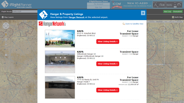
iFlightPlanner has incorporated Hangar Network’s real estate data into its flight planning tools.  Now hangars and airport properties that are for sale, lease or available as transient space are viewable as an interactive layer in all of iFlightPlanner’s web-based mapping interfaces.  An industry first, these new tools allow pilots to see all the space available at airports along their route of flight.

Whether buying or selling a hangar, seeking a home for a flight department or searching for transient space during an upcoming trip, iFlightPlanner and Hangar Network have brought together the best of both products to showcase all the real estate available along a flight route. Listings are updated by Hangar Network daily, allowing iFlightPlanner to provide one-click access to current, complete listing details and property information.

“Hangar Network strives to be the central resource for the aviation and airport real estate industry. Our mission is to change the way that aviators, industry professionals and the world connect to aviation real estate. By partnering with iFlightPlanner, we are revolutionizing the industry and demonstrating our ongoing commitment to finding new, better ways to navigate the aviation real estate market,” said Iver Retrum, co-founder and manager, Hangar Network. “By making this connection we are taking the first step toward creating a system where, in addition to exposing an airport’s long-term real estate options, aviators are able to communicate and make transient hangar accommodations available on a real-time basis.” 

“Partnering with Hangar Network has allowed us to add even more industry-leading functionality to iFlightPlanner. Whether pilots are simply viewing our freely accessible aviation charts or planning a detailed cross-country flight and filing flight plans, finding the airport real estate to meet their needs at home or on the go has never been easier,” said Andy Matthews, co-founder & director of business development for iFlightPlanner.

Pilots may choose to overlay any combination of Hangar Network listings along their route of flight by selecting their preferred property types from the Map Layers menu found in the upper-left corner of all iFlightPlanner’s online maps. Available hangars, land, airport residential space, tie down space and warehouse/flex space are all shown. 

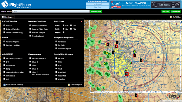
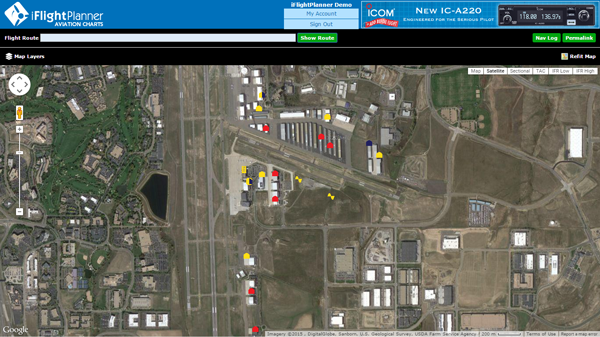
When zoomed out, iFlightPlanner’s intelligent zoom functionality will show a summarized total of listings at each airport, and when zoomed in, or by clicking the “Zoom to Satellite View” button, users can see the precise location of each listing on the airfield with color-coded identifiers indicating their respective availability. In addition to the graphical map layer, all of Hangar Network’s listings are also available through iFlightPlanner’s comprehensive Airport/Facility Directory on the Hangars & Properties tab available for each airport.


To add an airport property listing to Hangar Network for display on iFlightPlanner, visit http://www.HangarNetwork.com/Signup to create an account!

About Hangar Network

Hangar Network is the leading resource for connecting individuals to aviation real estate. Their map-centric listing service provides unmatched access to a diverse range of airport related real estate. Hangar Network has changed the way aviators, industry professionals and the world connect to aviation real estate. In addition to a state-of-the-art listing service, Hangar Network also provides users and subscribers with the latest industry news, expert advice and industry happenings through its social media channels, newsletter and blog. For more information, please visit www.HangarNetwork.com

Friday, August 21, 2015

FAA Ending Universal Flight Watch Weather Frequency

Friday, August 21, 2015 @ 8:00 AM

UPDATE: FAA Ending Universal Flight Watch Weather Frequency on 9/24

The FAA will discontinue the universal Flight Watch frequency 122.0 MHz for in-flight weather services on October 1. Weather services provided under the Flight Watch program Enroute Flight Advisory Service (EFAS) will continue to be provided via charted frequencies pilots use to obtain weather information, open and close flight plans, and for updates on notams and temporary flight restrictions.

The changes come as pilots transition "from traditional Flight Service assistance to more automated and web-based tools to obtain services. Through the use of updated technology Flight Service is taking the opportunity to eliminate redundancies and underutilized services," the FAA informed pilots in a message on its website.

Providing the weather services on local flight service frequencies will resolve issues of bleed-over and frequency congestion that have occurred on 122.0 MHz. Another advantage of the change will be the availability of the services on Flight Service frequencies monitored 24 hours a day, seven days a week, as opposed to the limited monitoring of 122.0 MHz, said Rune Duke, AOPA director of government affairs for airspace and air traffic.

After October 1, the FAA will continue to monitor 122.0 MHz for several months to assist pilots in locating a local frequency.

Thursday, August 20, 2015

FAA Airport, Navigation & Chart Data is Current for 8/20 Cycle

Thursday, August 20, 2015 @ 4:01 AM

Official airport, navigation and chart data for the FAA's 56-day cycle beginning 8/20/15 became current today as of 09:01Z.  This includes updated georeferenced data for airport diagrams and instrument approach procedures available in iFlightPlanner for iPad.

Anytime you access iFlightPlanner.com or mobile.iFlightPlanner.com you can be confident that you are seeing the most current and accurate data available.  To ensure that iFlightPlanner for iPad is current, simply tap "Check for Updates" in the upper-left corner of the Downloads tab.  The app will quickly tell you which packages need to be updated!

The iFlightPlanner Crew
PLAN. FLY. LOG.

Wednesday, August 19, 2015

New Online, Free VFR/IFR Chart Functionality

Wednesday, August 19, 2015 @ 8:00 AM

Celebrate National Aviation Day with a number of all-new planning functions you'll find on our freely accessible aviation charts interface, iFlightPlanner.com/AviationCharts!


  • Pressing enter key when the cursor is in route box plans the route
  • Added "GS" parameter for groundspeed in the Permalink
  • Clicking a waypoint ID in the Nav Log will zoom to that location on the map
  • Clicking Total Distance or Total Time in the Nav Log zooms out to the full route
  • Mousing over a route line now highlights the corresponding Nav Log segment
  • Waypoints may be reordered in the Nav Log by dragging and dropping
  • Most changes now result in an immediate route recalculation
  • Previous map type, route and groundspeed are now restored via cookies

All of these upgrades came as the direct result of feedback we received from pilots all across the country, and they have helped set the foundation for an exciting new partnership that we will be announcing very soon, so stay tuned!

Monday, August 17, 2015

FAA Airport, Navigation & Chart Data Available for 8/20 Cycle

Monday, August 17, 2015 @ 8:00 AM

iFlightPlanner for iPad users may now download airport and navigation data as well as aeronautical charts, georeferenced airport diagrams and terminal procedures for the FAA Data Cycle that goes into effect on August 20, 2015.  Simply tap the button in the upper-left corner of the Downloads tab to "Check For Updates".

Pilots using iFlightPlanner.com or mobile.iFlightPlanner.com from their smartphones will see the iFlightPlanner Cloud automatically make the transition to the new data at 9:01Z on August 20.

Monday, August 3, 2015

New Location Menu for Online Aviation Charts, Route Rubberbanding

Monday, August 3, 2015 @ 8:00 AM

On July 31 we launched the latest enhancements to iFlightPlanner.com.  As part of this update, we introduced updated maps functionality that is part of our ongoing effort to unify the user experiences found online and in iFlightPlanner for iPad.  The most noticeable feature change is the Location menu that is revealed when clicking anywhere on the map, allowing a lat/lon, airport, navaid or custom location to be added to a route with a single click.  This same menu will also allow you to access iFlightPlanner's graphical airspace functionality by clicking the adjacent Airspace button.

The nearby airports, navaids and custom locations can also be accessed by rubberbanding any existing waypoint or route segment to a new location.  This new flight planning functionality, aside from mirroring the usability of iFlightPlanner for iPad, is aimed at making the flight planning processes simpler and more efficient.

Should you have any questions about using this, or any other feature found in iFlightPlanner, please don't hesitate to contact us!

The iFlightPlanner Crew
PLAN. FLY. LOG.