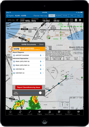
Georeferenced Airport Diagrams & Approach Procedures
iFlightPlanner for iPad v2.2, featuring the comprehensive set of georeferenced FAA airport diagrams and instrument approach procedures, is now available for download from the App Store!
As part of this release, the iFlightPlanner Crew developed its own, proprietary georeferencing process so that when viewed as standalone documents, iFlightPlanner for iPad could provide the georeferenced airport diagrams and approach procedures in their original PDF format - fully leveraging the pinch and zoom capabilities of the iPad with crystal clear readability at any zoom level.
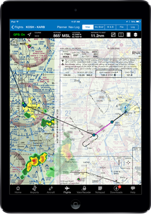
The georeferenced functionality is accessible throughout iFlightPlanner for iPad presented by Sennheiser, including its split-screen view, and can be easily placed over iFlightPlanner’s seamless VFR and IFR charts with a single tap of the "Map It" button. Pilots can then use the intuitive mini-menu to quickly search for and switch between other diagrams or approach procedures and adjust the transparency of each.
Anytime you see the aircraft icon in either the Airport/Facility directory or mini-menu (as shown above), that document is available to you as a georeferenced product when GPS is enabled on your device.
All georeferenced airport diagrams and approach procedures are available to iFlightPlanner Premium Plus members, a new membership level introduced to give pilots flying with iFlightPlanner for iPad greater functionality. Premium Plus annual memberships may be purchased for only $119.99 through August (reg. $139.99). Current iFlightPlanner Premium members who wish to upgrade to iFlightPlanner Premium Plus and prorate their existing membership may contact us for details!
Additional features in iFlightPlanner for iPad v2.2 include...
Airports
- Airports without an official FAA airport diagram will now show the A/FD page in the upper left thumbnail area.
Approach Plate Timer
- When viewing approach plates, we improved the usability of the timer by enlarging the tap area to open the timer and preventing the timer from moving up or down when the toolbar is hidden. iFlightPlanner for iPad will also now remember whether you last had the timer open or closed.
RADAR & Satellite Overlays
- You may now change the opacity of the RADAR and Satellite overlays. Simply tap the View/Split Screen Settings button above the map and move the slider. You may also save your default setting for future use!
TAC & IFR Low Charts
- We added an additional native zoom level to both the TAC and IFR Low charts tiles to enhance the readability when zooming in.
Downloads
- Unselected download types now will show as 50% transparent so that you can easily see which downloads will be performed when you tap "Download Updates."
