Beginning with the April 3, 2014 data cycle, the Federal Aviation Administration (FAA) began distributing new, high-resolution digital charts. Electronic flight planning resources, including iFlightPlanner.com, iFlightPlanner for iPad and all iFlightPlanner competitors who use the AeroNav Office's digital charting products benefit from the new production process.
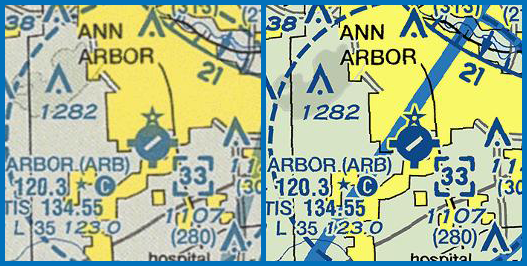
Previously, digital charts were distributed as scans of the actual paper charts that are sold by your local pilot shop. The AeroNav Office is now, in the simplest of terms, distributing the original graphics files that would be used to print the paper chart. The new process removes a time consuming step that also caused a significant loss in image quality, and the results are quite dramatic!
Since iFlightPlanner first introduced georeferenced charts, the iFlightPlanner Crew has used an internal, proprietary process that allows us to deliver all seamless U.S. VFR, IFR and TAC charts to our members at no cost. Pilots can be confident that anytime they are viewing charts on iFlightPlanner.com/AviationCharts, in the Flight Wizard or via iFlightPlanner for iPad they are seeing the most current and accurate data available. (To ensure that iFlightPlanner for iPad is current, simply tap the 'Check for Updates' button in the upper-left corner of the Downloads tab. The app will quickly tell you which files need to be updated!)
We know you'll enjoy the new visuals. Should you have any questions about the new charts please do not hesitate to contact us, we'll be happy to share any insight!
The iFlightPlanner Crew
PLAN. FLY. LOG.
