The USGS, along with numerous state and federal partners, has launched the 3D Elevation Program (3DEP), an effort to chart all 50 states with airborne lasers (lidar) or radar (ifsar). The new technology permits astonishingly precise measurements of terrain, buildings and roads, waterways, coastline, even vegetation, right down to individual plants.
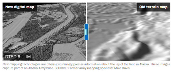
Alaska, it turns out, has never been mapped to modern standards. While the U.S. Geological Survey (USGS) is constantly refining its work in the lower 48 states, the terrain data in Alaska is more than 50 years old, much of it hand-sketched from black-and-white stereo photos shot from World War II reconnaissance craft and U-2 spy planes. Errors abound. Locals tell of mountains as much as a mile out of place. Streams flow uphill, and ridges are missing because a cloud happened by when the photo was taken.
Mars is better mapped than the state of Alaska,” said Steve Colligan, president of E-Terra, an Anchorage mapping firm that specializes in aviation safety.
» More from The Washington Post
